"The Lost Tunnels": Los Gatos to Santa Cruz Trail Run
My favorite training run takes me from my house in the hills above Los Gatos to Santa Cruz all on trails. From my house to the beach it's about 18 miles and a little under 3 hours. I've had people ask "how in the world is this possible to do this only on trails"? This trail happens to follow the old railroad grade from Los Gatos to Santa Cruz. One of the most intriguing things about the old railroad grade is all of the tunnels that are present on it, as documented by Ray Hosler.
As a dedicated bushwhacker of the hidden trails of the Santa Cruz mountains, I've come across most of these tunnels. I thought I would document the trail path from the Summit area of the Santa Cruz mountains to the Santa Cruz beach via the old railroad grade. And at the same time provide some recent photos of tunnels that people haven't seen. For example Ray Hosler's site does not show the south end of the Zayante Tunnel (what I refer to as portal #8).
I'll start at the first of the tunnels, Wright's Tunnel and continue from there along the route of the old railroad grade as much as possible (obviously when we hit the tunnels we have to run around them. The entire length of the route is right around 50K. Pictures of the whole route are available on Flickr.
To get to the north end of Wright's Tunnel (portal #1) go east on Summit Road from Route 17. Make a left on Morrill Cutoff and then another left on Wright's Station. You'll then see this on your left.
tree marking path to Wright's Tunnel, Portal #1
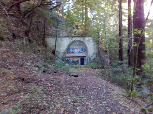
You can see the tunnel hole behind the tree. Going over the fence and down the path you'll see this large tunnel portal.
Wright's Tunnel, Portal #1
To get to the "other side" of Wright's Tunnel you can either attempt to dig past the dynamited entrance, or go up back to Summit, take a right and go down past Sunset Drive on the left and take the next left on Summit Canyon Road. At this point you've gone about two miles. If you keep bearing to the right it will take you down to the logging road that leads to the tunnel. Here is portal #2, the other side of Wright's Tunnel:
From portal #2 get up onto the railbed by climbing up to the west. Then run on the railbed (ducking under and climbing over fallen trees) for about two miles. The railbed will end at a ravine across from a house. Climb down the ravine and back up into that driveway. It turns into a trail that runs into the town of Laurel and you will see portal #3 straight ahead.
Glenwood Tunnel, Laurel Side, Portal #3
The map below shows the general vicinity of portals 1 through 3.
Its about 5 miles total between portal #1 to portals #2 and #3, assuming a bushwhack from portal 2 to 3.
View Larger Map
To get to the other side of this tunnel, you'll go down Schulties to Laurel Road, make a right and then hit Route 17th South. Going down 17 to Glenwood Cutoff and making a right will drop you off on Glenwood Road. Heading up Glenwood Road to Eagle Road on your right, you'll see the Glenwood tunnel south portal (portal #4) on your left. This is about 3.5 miles.
Glenwood Tunnel, Glenwood Side, Portal #4
Heading back south on Glenwood Road, you'll go past Glenwood Cutoff and then you'll see a driveway on your right that will connect over to the old railroad grade path. Its a little under a mile to here. So far we've gone about 9 miles.
Through the trees you can then see the Mountain Charlie tunnel Glenwood portal (portal #5), ahead. This portal is impressive and is seen by very few people in its remote location in the woods. Here's a map of the general area between Laurel and Glenwood.
View Larger Map
Since it's a bit hard to find if you have a GPS it's located at 37.098 degrees north and 122 degrees west. You can also get a fix on it from Google Earth by looking for Clems, CA, which will get you very close to the tunnel itself. Note that none of the tunnels are visible from Google Earth due to the very dense tree cover on almost all of the trail. The tree cover is also an issue as far as getting GPS coordinates for the other tunnels. But your GPS device should work at this portal.
Mountain Charlie Tunnel, Glenwood Side, Portal #5
If you bushwhack up the hill above the tunnel (trying to follow what train must have done underneath the mountain), you'll end up on Mountain Charlie Road. At that point you'll see Schoolhouse Road ahead of you perpendicular to Mountain Charlie. Follow that road past a couple houses, a horse barn and a chicken coop to what seems like a dead end, but where it turns into a dirt driveway. When it gets to the bottom it will reach a fork, the left one is well maintained and leads down for half a mile to someone's house (!). Don't take this fork. Stay to the right where its overgrown. After a couple hundred yards you'll see this incredible view of the Mountain Charlie tunnel, south portal (what I call portal #6), one of the least viewed anywhere.
Mountain Charlie Tunnel, South Side, Portal #6
Now heading back out to the fork, stay going east (don't go back up the hill) and you're on the railroad grade that takes you all the way to Santa Cruz in a straight shot. This is basically where I pick up the trail from my house. This is one of my favorite places to run on the planet and I can go hours here many days in a row never seeing a car, house or person. Lots of deer, raccoons, bats, and, yes, mountain lions, though.
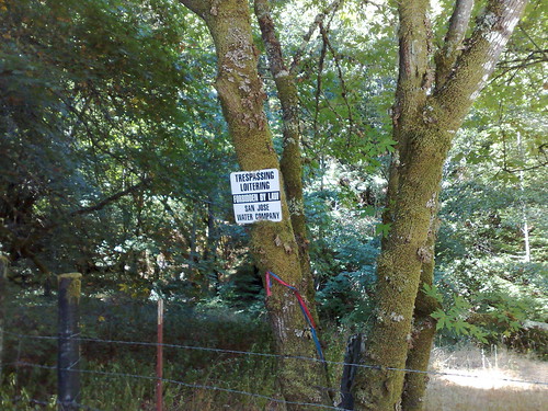
Santa Cruz water company property fence along the railroad grade (which there is an easement for)
After you run for several miles on this flat and wide but beautiful and incredibly private and remote trail, it runs into someone's backyard as you approach Zayante. See the Flickr set for more details of this idyllic portion of the run. But just stay to the left here and you'll see single track that climbs up a hill. As you climb the hill it lets back out onto flat wide railroad grade path again and you'll see the Zayante tunnel ahead.
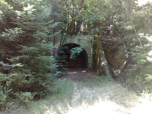
Zayante Tunnel, North Side, Portal #7
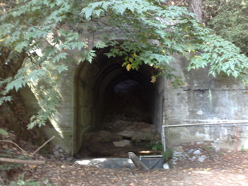
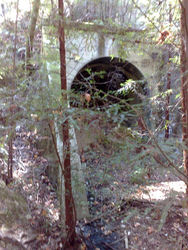
Passing that tunnel you climb up and over a hill and you'll come out after a couple hundred feet to the Zayante tunnel South Portal. This portal, portal #8, is taken over by a records storage facility. Note that no pictures of this portal appear on Ray Hosler's site (perhaps because the entrance is obscured by the building?).
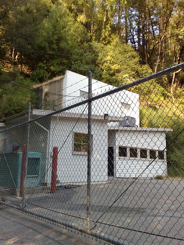
Zayante Tunnel, South Side, Portal #8
Bushwhacking around this building you'll come out on a path on the other end that leads to Old Kenville Road, an unlabeled dirt trail. Following this road it lets out onto Zayante Schoolhouse Road, which you'll follow for a hundred feet or so until you see this on your right. The total distance from the last real road (portal #5 on Glenwood Road) is probably about 5 miles. Thus we've traveled about 14 miles so far.
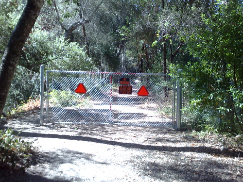
fence off of Zayante Schoolhouse Road behind which is path leading to tracks
Following the trail behind the fence for a hundred feet or so, you'll reach a sandy area and the beginning of the old actual train tracks.
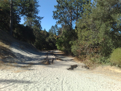
Beginning of old railroad tracks!
After a few miles the tracks will reach Felton and Graham Hill Road, and the Big Trees Railroad train depot. Keep going straight across Graham Hill and into the Big Trees Railroad Depot. There are lots of runners who run Henry Cowell Redwoods up to the depot and back, so noone will bother you here.
Here's a map showing the area from Glenwood to Zayante down to Felton. You can see that its about 5 miles from Zayante to Big Trees Railroad depot in Felton by road and the railroad tracks parallel. So far we've gone about 19 miles.
View Larger Map
Note that you can also go to the right on Graham Hill Road to grab a coffee in Felton (the White Raven on Route 9 just below Graham Hill) as a quick break, picking up the railroad tracks again from the Henry Cowell entrance. This adds about a mile to the trip.
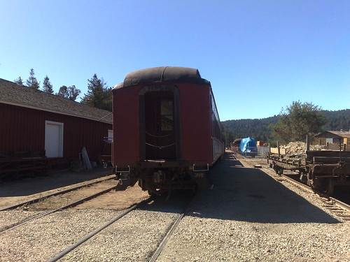
train at Santa Cruz Big Trees Railroad Depot in Felton
After a section of passing the parked trains for the Big Trees Railroad (including a narrow gauge train heading out east to Bear Mountain shown here). There is a nice trail alongside the standard gauge track all from here going into Henry Cowell Redwoods Park.
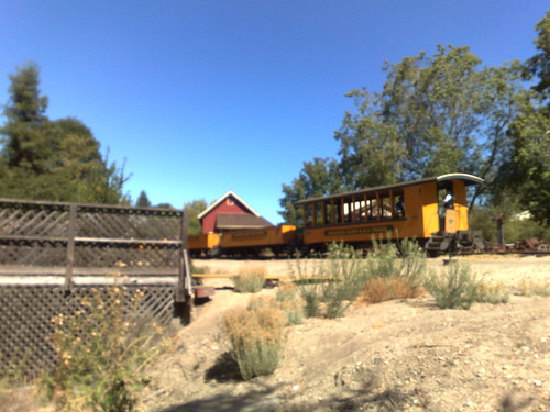
narrow gauge train leaving east up to Bear Mountain, seen from the standard gauge track
After this point it enters into Henry Cowell, a beautiful heavily forested state park with much firstgrowth redwood. After going over the San Lorenzo River and paralleling the river for several miles it crosses over Route 9 and the tracks continue on the west side of 9 in Pogonip Park.
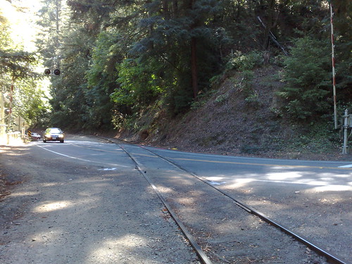
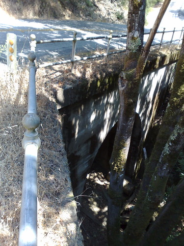
crossing Route 9 from Henry Cowell to Pogonip Park
After a hair-raising railroad bridge crossing it reaches Santa Cruz, crosses over Route 1, and continues on to the Chestnut Street bridge, which probably counts as the final tunnel (and thus portals #9 and #10). I don't always run this part through the tunnel because it's not that pleasant, often choosing to get a coffee on Pacific Avenue instead. In either case (the tracks through Chestnut Street or ambling along the shops of Pacific), continuing on drops you off at the beach.
The following map shows the nine mile run on the tracks (roughly paralleling route 9) from Felton to Santa Cruz. Thus the whole tunnel run is about 29 miles.
View Larger Map
A dip in the surf is the perfect end to an amazing run. At this point, you can run back up the hill (which my friend Pierre did when he ran it with me), take the bus back up to Summit, or meet some friends on the beach for a ride back up. I recommend option 3.

the wharf in Santa Cruz
I'm tentatively planning a fatass (unorganized trail race) for a bunch of my local ultrarunner friends on this route for Saturday, November 1st. I'll be making another post on this blog to outline the logistics of that run.
As a dedicated bushwhacker of the hidden trails of the Santa Cruz mountains, I've come across most of these tunnels. I thought I would document the trail path from the Summit area of the Santa Cruz mountains to the Santa Cruz beach via the old railroad grade. And at the same time provide some recent photos of tunnels that people haven't seen. For example Ray Hosler's site does not show the south end of the Zayante Tunnel (what I refer to as portal #8).
I'll start at the first of the tunnels, Wright's Tunnel and continue from there along the route of the old railroad grade as much as possible (obviously when we hit the tunnels we have to run around them. The entire length of the route is right around 50K. Pictures of the whole route are available on Flickr.
To get to the north end of Wright's Tunnel (portal #1) go east on Summit Road from Route 17. Make a left on Morrill Cutoff and then another left on Wright's Station. You'll then see this on your left.
tree marking path to Wright's Tunnel, Portal #1
You can see the tunnel hole behind the tree. Going over the fence and down the path you'll see this large tunnel portal.
Wright's Tunnel, Portal #1
To get to the "other side" of Wright's Tunnel you can either attempt to dig past the dynamited entrance, or go up back to Summit, take a right and go down past Sunset Drive on the left and take the next left on Summit Canyon Road. At this point you've gone about two miles. If you keep bearing to the right it will take you down to the logging road that leads to the tunnel. Here is portal #2, the other side of Wright's Tunnel:
From portal #2 get up onto the railbed by climbing up to the west. Then run on the railbed (ducking under and climbing over fallen trees) for about two miles. The railbed will end at a ravine across from a house. Climb down the ravine and back up into that driveway. It turns into a trail that runs into the town of Laurel and you will see portal #3 straight ahead.
Glenwood Tunnel, Laurel Side, Portal #3
The map below shows the general vicinity of portals 1 through 3.
Its about 5 miles total between portal #1 to portals #2 and #3, assuming a bushwhack from portal 2 to 3.
View Larger Map
To get to the other side of this tunnel, you'll go down Schulties to Laurel Road, make a right and then hit Route 17th South. Going down 17 to Glenwood Cutoff and making a right will drop you off on Glenwood Road. Heading up Glenwood Road to Eagle Road on your right, you'll see the Glenwood tunnel south portal (portal #4) on your left. This is about 3.5 miles.
Glenwood Tunnel, Glenwood Side, Portal #4
Heading back south on Glenwood Road, you'll go past Glenwood Cutoff and then you'll see a driveway on your right that will connect over to the old railroad grade path. Its a little under a mile to here. So far we've gone about 9 miles.
Through the trees you can then see the Mountain Charlie tunnel Glenwood portal (portal #5), ahead. This portal is impressive and is seen by very few people in its remote location in the woods. Here's a map of the general area between Laurel and Glenwood.
View Larger Map
Since it's a bit hard to find if you have a GPS it's located at 37.098 degrees north and 122 degrees west. You can also get a fix on it from Google Earth by looking for Clems, CA, which will get you very close to the tunnel itself. Note that none of the tunnels are visible from Google Earth due to the very dense tree cover on almost all of the trail. The tree cover is also an issue as far as getting GPS coordinates for the other tunnels. But your GPS device should work at this portal.
Mountain Charlie Tunnel, Glenwood Side, Portal #5
If you bushwhack up the hill above the tunnel (trying to follow what train must have done underneath the mountain), you'll end up on Mountain Charlie Road. At that point you'll see Schoolhouse Road ahead of you perpendicular to Mountain Charlie. Follow that road past a couple houses, a horse barn and a chicken coop to what seems like a dead end, but where it turns into a dirt driveway. When it gets to the bottom it will reach a fork, the left one is well maintained and leads down for half a mile to someone's house (!). Don't take this fork. Stay to the right where its overgrown. After a couple hundred yards you'll see this incredible view of the Mountain Charlie tunnel, south portal (what I call portal #6), one of the least viewed anywhere.
Mountain Charlie Tunnel, South Side, Portal #6
Now heading back out to the fork, stay going east (don't go back up the hill) and you're on the railroad grade that takes you all the way to Santa Cruz in a straight shot. This is basically where I pick up the trail from my house. This is one of my favorite places to run on the planet and I can go hours here many days in a row never seeing a car, house or person. Lots of deer, raccoons, bats, and, yes, mountain lions, though.
Santa Cruz water company property fence along the railroad grade (which there is an easement for)
After you run for several miles on this flat and wide but beautiful and incredibly private and remote trail, it runs into someone's backyard as you approach Zayante. See the Flickr set for more details of this idyllic portion of the run. But just stay to the left here and you'll see single track that climbs up a hill. As you climb the hill it lets back out onto flat wide railroad grade path again and you'll see the Zayante tunnel ahead.
Zayante Tunnel, North Side, Portal #7
Passing that tunnel you climb up and over a hill and you'll come out after a couple hundred feet to the Zayante tunnel South Portal. This portal, portal #8, is taken over by a records storage facility. Note that no pictures of this portal appear on Ray Hosler's site (perhaps because the entrance is obscured by the building?).
Zayante Tunnel, South Side, Portal #8
Bushwhacking around this building you'll come out on a path on the other end that leads to Old Kenville Road, an unlabeled dirt trail. Following this road it lets out onto Zayante Schoolhouse Road, which you'll follow for a hundred feet or so until you see this on your right. The total distance from the last real road (portal #5 on Glenwood Road) is probably about 5 miles. Thus we've traveled about 14 miles so far.
fence off of Zayante Schoolhouse Road behind which is path leading to tracks
Following the trail behind the fence for a hundred feet or so, you'll reach a sandy area and the beginning of the old actual train tracks.
Beginning of old railroad tracks!
After a few miles the tracks will reach Felton and Graham Hill Road, and the Big Trees Railroad train depot. Keep going straight across Graham Hill and into the Big Trees Railroad Depot. There are lots of runners who run Henry Cowell Redwoods up to the depot and back, so noone will bother you here.
Here's a map showing the area from Glenwood to Zayante down to Felton. You can see that its about 5 miles from Zayante to Big Trees Railroad depot in Felton by road and the railroad tracks parallel. So far we've gone about 19 miles.
View Larger Map
Note that you can also go to the right on Graham Hill Road to grab a coffee in Felton (the White Raven on Route 9 just below Graham Hill) as a quick break, picking up the railroad tracks again from the Henry Cowell entrance. This adds about a mile to the trip.
train at Santa Cruz Big Trees Railroad Depot in Felton
After a section of passing the parked trains for the Big Trees Railroad (including a narrow gauge train heading out east to Bear Mountain shown here). There is a nice trail alongside the standard gauge track all from here going into Henry Cowell Redwoods Park.
narrow gauge train leaving east up to Bear Mountain, seen from the standard gauge track
After this point it enters into Henry Cowell, a beautiful heavily forested state park with much firstgrowth redwood. After going over the San Lorenzo River and paralleling the river for several miles it crosses over Route 9 and the tracks continue on the west side of 9 in Pogonip Park.
crossing Route 9 from Henry Cowell to Pogonip Park
After a hair-raising railroad bridge crossing it reaches Santa Cruz, crosses over Route 1, and continues on to the Chestnut Street bridge, which probably counts as the final tunnel (and thus portals #9 and #10). I don't always run this part through the tunnel because it's not that pleasant, often choosing to get a coffee on Pacific Avenue instead. In either case (the tracks through Chestnut Street or ambling along the shops of Pacific), continuing on drops you off at the beach.
The following map shows the nine mile run on the tracks (roughly paralleling route 9) from Felton to Santa Cruz. Thus the whole tunnel run is about 29 miles.
View Larger Map
A dip in the surf is the perfect end to an amazing run. At this point, you can run back up the hill (which my friend Pierre did when he ran it with me), take the bus back up to Summit, or meet some friends on the beach for a ride back up. I recommend option 3.
the wharf in Santa Cruz
I'm tentatively planning a fatass (unorganized trail race) for a bunch of my local ultrarunner friends on this route for Saturday, November 1st. I'll be making another post on this blog to outline the logistics of that run.
posted by Adam Blum at 6:30 PM
9 comments
![]()
![]()


